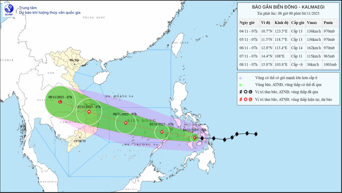
According to the National Center for Hydro-Meteorological Forecasting, Kalmaegi entered the central Philippines late on November 3 with a strength of level 13.
By the early hours of November 5, the typhoon will move into the East Sea and become the 13th tropical storm to form in the region this year, continuing to gain strength.
Domestic and international forecasting models generally agree that the typhoon will make direct landfall in the South-Central region of Vietnam with very strong intensity. However, there are still discrepancies in predicted landfall zones and storm strength across different models.
Meteorologists from the National Center for Hydro-Meteorological Forecasting predict that once in the East Sea, the typhoon will move west-northwest at 20–25 km/h until it reaches the South-Central coast. Once it enters the East Sea, updates will be issued every three hours, and hourly in the event of an emergency.
Forecasts suggest that on November 6, the typhoon could reach its peak intensity at level 14, the strongest level for this storm. Due to its rapid movement, Kalmaegi is expected to make landfall earlier than usual.
"The storm's center will likely move inland across provinces from Quang Ngai to Dak Lak (formerly Phu Yen) on the morning of November 7," one expert stated.
Authorities are advising offshore vessels and fish farming households operating from Da Nang to Khanh Hoa to urgently prepare for the approaching typhoon.
Landfall expected with strength up to level 11
Meteorologists note that Kalmaegi is unlikely to encounter weakening factors such as dry cold air or strong wind shear that caused super typhoons like Ragasa (Storm No. 9) and Fengshen (Storm No. 12) to dissipate.
Therefore, this could be the strongest typhoon to make landfall in Vietnam this year, potentially as severe or even more dangerous than Typhoon Bualoi, which struck Ha Tinh and Nghe An in late September.
Kalmaegi is expected to be about 400 km off the coast of Gia Lai by the morning of November 6, with gusts reaching level 17.
By the night of November 6, the typhoon may directly impact areas from Da Nang to Khanh Hoa. Coastal regions, including Ly Son Island, could experience winds of level 12–13 with gusts exceeding level 15. Inland coastal areas may experience winds of level 10–12 and gusts of level 14–15.
By 7:00 a.m. on November 7, the storm's center is projected to be overland across provinces from Quang Ngai to Dak Lak, with winds of level 10–11 and gusts of up to level 13.
Experts also warn that the storm may bring pre-landfall thunderstorms and tornadoes. Heavy rainfall is expected across a wide area from Quang Tri to Dak Lak between the nights of November 6–9. There is a risk of new flooding across rivers in provinces from Quang Tri to Khanh Hoa.
The weather authority emphasized that current observations and forecasts still contain uncertainties regarding the storm's path, strength, and trajectory. Rainfall locations and volumes in the coming days may also fluctuate. Therefore, ministries, local authorities, and residents must closely monitor forecasts and warnings to take proactive safety measures.
Immediately from the afternoon of November 4, the eastern waters of the central East Sea are expected to experience strengthening winds of level 6–7, later increasing to level 8–10. Near the storm center, winds may reach level 11–13 with gusts of level 15–16, and waves as high as 5–7 meters. Conditions at sea will be extremely rough.
From November 5–6, the central East Sea (including the northern sea area of the Truong Sa Archipelago) and offshore waters from Da Nang to Khanh Hoa will likely face winds of level 12–14, gusting beyond level 17, with waves of 8–10 meters. The sea will be extremely rough.
All vessels and offshore facilities in the high-risk zones will be severely affected by thunderstorms, strong winds, and high waves.
Bao Anh