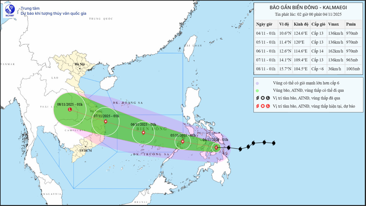
According to the National Center for Hydro-Meteorological Forecasting (NCHMF), as of 1:00 a.m. on November 4, Typhoon Kalmaegi’s center was located over central Philippines with sustained winds of level 13 (134–149 km/h) and gusts up to level 16. This marks an increase of two wind levels compared to the morning of November 3.
The storm is currently moving westward at a fast pace of 25 km/h.
Forecast path and intensity
Within the next 24 hours: Kalmaegi is expected to move west-northwest at 20–25 km/h. By 1:00 a.m. on November 5, it will be over the western part of central Philippines with wind strength of level 12–13 and gusts up to level 16.
Early November 5: The storm will enter the East Sea, becoming Typhoon No.13 of 2025. It is expected to intensify further.
By 1:00 a.m. on November 6: Kalmaegi’s center will be located in the central East Sea, about 630 km east-southeast of Gia Lai Province’s coastline, with peak intensity of level 14 and gusts up to level 17.
By 1:00 a.m. on November 7: The storm will approach coastal waters from Quang Ngai to Dak Lak, slightly weakening to level 13, gusting to level 16.
By 7:00 a.m. the same day: Kalmaegi is forecast to move inland over provinces between Quang Ngai and Dak Lak, sustaining wind speeds of level 10–11 and gusts to level 13.
From 72 to 96 hours onward: Kalmaegi will continue moving west-northwest at 20–25 km/h and gradually weaken.
Impacts expected
Meteorological experts warn that Kalmaegi could begin to directly affect the central region from the night of November 6, particularly the area from Da Nang to Khanh Hoa:
Coastal areas, including Ly Son Island, may experience winds of level 12–13, with gusts above level 15.
Inland zones may see wind speeds of level 10–12, gusting to levels 14–15.
The storm may trigger thunderstorms and tornadoes ahead of landfall.
A broad area of heavy rainfall is forecast for November 6–9, stretching from Quang Tri to Dak Lak, potentially causing new flood events on rivers in the region.
The weather agency emphasized that forecast data regarding the storm’s track, intensity, and rainfall distribution remains subject to change, and authorities and the public should closely monitor updates.
Dangerous marine conditions
Starting this afternoon (November 4), due to the storm’s influence:
The eastern part of the central East Sea will see wind speeds increasing to level 6–7, later reaching level 8–10.
Areas near the storm’s center could see wind levels 11–13 with gusts up to 15–16.
Wave heights could reach 5–7 meters, with seas becoming extremely rough.
From November 5 to 6: The central East Sea, including the Truong Sa (Spratly) Archipelago, and offshore areas from Da Nang to Khanh Hoa are forecast to experience winds of level 12–14, gusting above level 17, and waves as high as 8–10 meters.
All vessels, offshore projects, and activities within the affected areas are advised to take urgent precautions against strong winds, rough seas, thunderstorms, and tornadoes.
Bao Anh