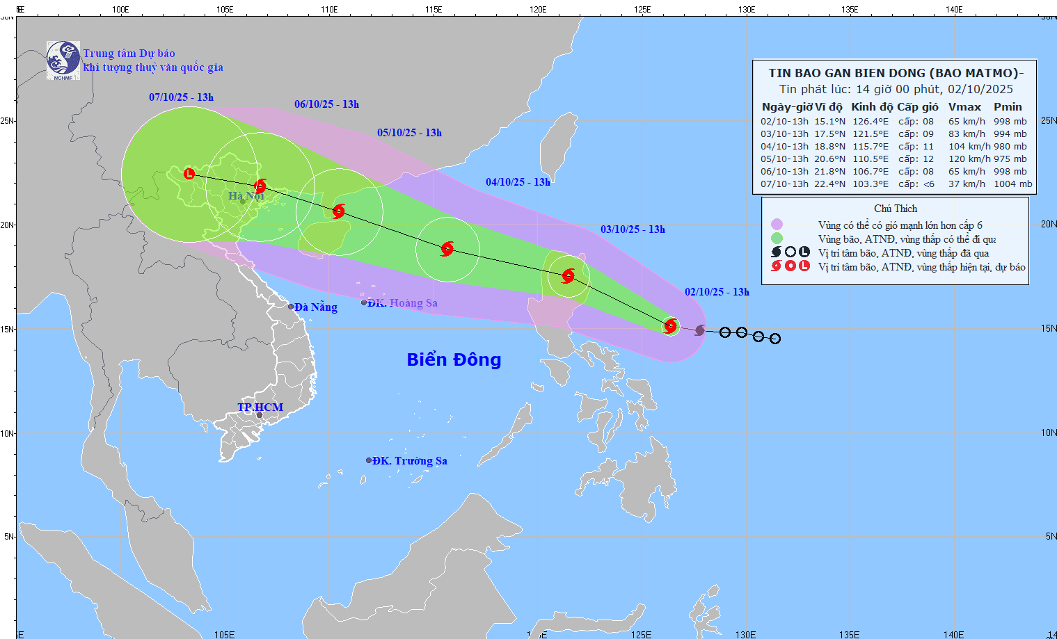
According to the National Center for Hydro-Meteorological Forecasting, as of 1 p.m. on October 2, the eye of Typhoon Matmo was located over the eastern waters of the Philippines. The strongest winds near the center were at level 8 (62-74 km/h), gusting to level 10. The storm is moving west-northwest at approximately 25km/h.
This means Typhoon Matmo is currently just 650km from the East Sea. Forecasts indicate that by the evening of October 3, it will enter the East Sea and become the 11th named storm of the 2025 rainy season. By around October 6, it will have a direct impact on northern Vietnam.
Direction and strength intensify as storm nears East Sea
In the next 24 hours, the typhoon is expected to maintain its west-northwest path at around 25km/h and may intensify further. By 1 p.m. on October 3, its center will likely be over the northern landmass of Luzon Island (Philippines), with wind speeds increasing to level 9 and gusts up to level 11.
In the following 24 hours, it will continue on its path into the East Sea, traveling at 25-30km/h and likely gaining strength. By 1 p.m. on October 4, the center of Typhoon Matmo is forecast to be over the eastern waters of the northern East Sea, about 430km northeast of the Hoang Sa (Paracel) Archipelago. At this time, the storm is expected to reach levels 10-11, with gusts up to level 13.
Another 24 hours later, it will maintain its west-northwest direction at a speed of about 25km/h and may continue to strengthen. By 1 p.m. on October 5, the storm’s center will be near the southern coast of the Leizhou Peninsula (China), with maximum sustained winds rising to level 12 and gusts up to level 15.
From 72 to 120 hours onward, the storm will continue moving west-northwest at 15-20km/h, with its intensity gradually decreasing.
Strong winds and rough seas forecast in East Sea
Due to the impact of Typhoon Matmo, starting from midday to the afternoon of October 3, the eastern part of the northern East Sea will experience increasing winds at levels 6-7, later reaching levels 8-9. Areas near the storm center will see winds of levels 10-11, gusting to level 12, with sea waves reaching 4-6 meters. The sea will be very rough.
Between October 4 and 5, the northern East Sea is likely to be hit by strong winds at levels 11-12, gusting to level 15. All vessels operating in the affected areas may be impacted by thunderstorms, gales, high winds, and large waves.
Bao Anh