On the morning of August 23, the National Center for Hydro-Meteorological Forecasting held an emergency meeting to coordinate response measures for Storm No. 5 (Kajiki) and meteorological services for the national A80 celebrations and local events.
According to forecasts, Storm Kajiki is a powerful system moving at high speed, with winds reaching level 12 and gusts of level 14-15. It poses a significant threat both at sea and on land across areas from Thanh Hoa to Quang Tri, endangering people, infrastructure, vessels, and coastal communities.
Particularly concerning is the potential for severe rainfall exceeding 200mm within three hours, which raises the risk of flash floods, landslides, and inundation, especially near dams and reservoirs. With less than a day remaining to prepare, the urgency of preventive action is critical.
Following landfall on August 25, heavy rains are forecast to spread across northern Vietnam, coinciding with intense rehearsals for national events related to the A80 celebration.
The Ministry of Agriculture and Environment, along with the Meteorological Agency, has instructed forecasting units to increase field operations, expand mobile monitoring points, and utilize all available technical resources. They have also emphasized data sharing with international partners to ensure accurate and timely forecasts aimed at minimizing disaster risks.
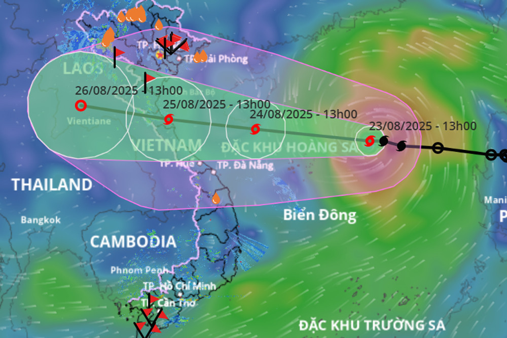
Current location and path of Storm Kajiki
As of 1:00 PM on August 23, the National Center for Hydro-Meteorological Forecasting reported the storm's center located approximately 300 kilometers east-northeast of the Hoang Sa (Paracel) Islands. The strongest winds near the storm's eye reached level 9 (75–88 km/h), with gusts of level 11. The storm is moving west-northwest at a speed of 25 km/h.
Over the next 24 hours, the storm will continue in the same direction, intensifying further. By 1:00 PM on August 24, its center is expected to be over the southern sea of Hainan Island (China), with wind intensity reaching level 11–12 and gusts of level 14.
In the following 24 hours, the storm will maintain its direction but slow down slightly to 15–20 km/h. By 1:00 PM on August 25, it will reach coastal waters from Thanh Hoa to Quang Tri, with wind strength at level 12 and gusts up to level 15.
In the 24 hours after that, Kajiki is expected to weaken into a tropical depression as it moves inland over central Laos.
Violent seas and coastal flooding warnings
Storm No. 5 will cause rough seas in the northern East Sea region (including the Hoang Sa area), with winds at levels 8–9 and gusts reaching level 14. Waves are expected to reach heights of 4–6 meters.
From the afternoon of August 24, the sea areas from Thanh Hoa to Hue (including Con Co and Hon Ngu islands) will experience increasing winds at levels 6–8, escalating to levels 9–10. In areas near the storm’s center, winds may reach levels 11–13 with gusts of level 15. Waves could surge up to 6–8 meters, and the sea will be extremely rough.
From the evening of August 24, the northern part of the Gulf of Tonkin (including Bach Long Vi island) will also see increasing wind levels of 6–7, with gusts of level 9 and wave heights of 2–4 meters.
The storm will trigger coastal flooding from Ninh Binh to northern Quang Tri, with expected storm surges of 0.5 to 1.2 meters. Sea levels may rise to 3.6 meters in Sam Son (Thanh Hoa), 3.8 meters in Hon Ngu (Nghe An), 2.8 meters in Vung Ang (Ha Tinh), and 2 meters in Cua Gianh (Quang Tri). Low-lying areas, estuaries, and islands face a high risk of flooding.
Meteorological authorities warn that all maritime and coastal activities, including passenger transport, aquaculture, and port infrastructure, are at serious risk. Strong winds, high waves, and storm surges could lead to capsizing, damage, and extensive flooding.
Rainfall projections and disaster risk
From the night of August 24, inland areas from Thanh Hoa to Quang Tri will face increasing winds up to level 9, with gusts reaching level 15 near the storm’s center.
Between August 24 and 26, heavy rainfall is forecast to spread from the Red River Delta and southern Phu Tho to Hue. Rainfall totals will range from 100–150mm, with localized areas receiving over 250mm. Particularly, areas from Thanh Hoa to Quang Tri may receive 150–300mm, with some areas exceeding 600mm.
Authorities are issuing warnings for extreme rainfall intensity, potentially exceeding 200mm within a 3-hour window.
From August 25–26, Hanoi and Danang are expected to receive moderate to heavy rainfall and thunderstorms. Ho Chi Minh City may see evening and nighttime showers, with risks of strong winds and tornadoes during storms.
From August 25–27, heavy rainfall ranging from 100–250mm is expected in upper and central Laos, with some central regions potentially exceeding 500mm.
‘Unusual’ features of Storm Kajiki and areas of highest concern
Kajiki’s rapid formation and intensification are being closely monitored. According to Dr. Hoang Phuc Lam, Deputy Director of the National Center for Hydro-Meteorological Forecasting, the storm's fast-moving nature and strength will heavily impact the provinces of Nghe An, Ha Tinh, and Quang Tri.
He highlighted that August 25 will be the peak period for strong winds and torrential rainfall across central Vietnam. Wind speeds of level 12 with gusts up to level 15 are expected to affect both coastal and inland regions.
Dr. Lam also emphasized that post-storm rainfall will likely spread into northern Vietnam and extend across mountainous areas of Nghe An and Ha Tinh.
Kajiki’s expected rainfall intensity of over 200mm in three hours poses a severe threat of flash floods and landslides, especially in mountainous areas of Thanh Hoa, Nghe An, and Ha Tinh between August 25 and 26.
Authorities have assigned risk levels as follows: from Thanh Hoa to Hue - level 3 (high) risk at sea, level 4 (very high) at the coast; from Hue to Lam Dong - level 2 at sea, level 3 at the coast; from Ho Chi Minh City to Ca Mau - level 2; and for the northern East Sea and the Gulf of Tonkin (including Hoang Sa and Bach Long Vi) - level 3.
Bao Anh